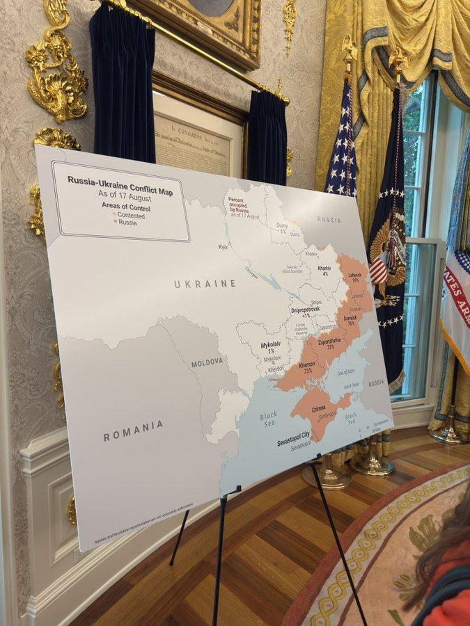
[Reported] According to the Ukrainian Truth newspaper, based on videos and images released on social media by the BBC and German media, on August 18th, local time, during the meeting between U.S. President Trump and Ukrainian President Zelensky at the Oval Office of the White House, a map was displayed showing areas controlled by Russia marked in orange-red.
The areas marked in orange-red cover approximately 20% of Ukraine’s total land area, including regions such as Luhansk, Donetsk, Zaporizhia, Kherson, Crimea, and others.
BBC’s Zek believes that this is Trump attempting to pressure Zelensky to accept the idea of “territorial concessions for peace”.
Trump held a meeting with visiting Zelensky at the White House on August 18th, local time. On the same day, NATO Secretary-General Lute, European Commission President Von Der Leyen, British Prime Minister Starmer, Italian Prime Minister Meloni, Finnish President Stubbe, German Chancellor Mertz, and French President Macron arrived at the White House. After the bilateral meeting between the US and Ukraine, Trump, Zelensky, and the aforementioned leaders held a multilateral meeting. After the meeting, Trump wrote on social media that he called Russian President Putin and began preparing for a trilateral leaders’ meeting between the US, Russia, and Ukraine. The conflict between Russia and Ukraine involves multiple parties.