The “Unified Geological Bureau” of the Russian Academy of Sciences’ Kamchatka branch reported that a 8.7 magnitude earthquake occurred near the Kamchatka Peninsula on July 30, marking the strongest earthquake in the region since 1952.
On the same day, two 6.5 and 5.3 magnitude earthquakes were also recorded near the coast of the Kamchatka Peninsula. Moreover, after the strong quake, over 100 aftershocks of magnitude 5 or above have occurred.
Affected by the strong quake, several countries along the Pacific coast issued tsunami warnings or alerts, with many areas observing tsunami waves. Where is the Kamchatka Peninsula? What is the cause of the earthquake? How significant is its impact?
The Kamchatka branch of the “Unified Geological Bureau” of the Russian Academy of Sciences stated that the epicenter of the earthquake was 161 kilometers from the capital city of the Kamchatka Territory—Kamchatka Petropavlovsk-Sakhalinsky. Images captured by local residents using their mobile phones showed the earthquake was extremely violent.
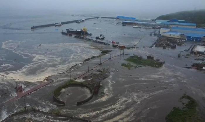
Affected by the strong quake, some regions in Russia experienced tsunamis. In parts of the Kamchatka Peninsula and parts of Sakhalin Oblast south of the peninsula, tsunamis of several meters high were observed following the earthquake. Approximately 2,700 people have been evacuated to safe areas.
The Kamchatka Peninsula is Russia’s second-largest peninsula, located in the Far East of Russia and part of the Kamchatka Territory. It is situated along the Pacific Ring of Fire, one of the most active regions for earthquake activity in Russia and globally. The peninsula is home to over 300 volcanoes, including 28 to 36 active ones.
In the Kamchatka region, the collision between the Pacific Plate and the Okhotsk Plate has led to relatively active volcanic activity. On July 30, the Kamchatka branch of the Russian Academy of Sciences’ Earth Physics Institute reported that the active volcano Klyuchevskaya erupted due to the earthquake.
The Kamchatka Peninsula has experienced multiple strong earthquakes and tsunamis in its history.
For instance, in 1952, a magnitude 9 earthquake struck Kamchatka, triggering a tsunami that affected Hawaii and South America. In 2006 and 2013, similar magnitude 8 or so strong quakes also occurred here. Therefore,
this region is among the few globally with a high risk of experiencing super-large earthquakes,
and it is also a focus area for global tsunami warning systems.
High-risk areas require vigilance, but the Earth has not entered “the shaking mode”
Experts point out that from a geological perspective, earthquakes are normal ways for the Earth to release tectonic stresses. It cannot be concluded that the Earth has entered “the shaking mode” simply because a major earthquake occurs. The long-term trend of global strong earthquakes is generally stable, meaning approximately 15 to 20 events of earthquakes above magnitude 7 occur annually worldwide. During certain periods, the frequency of earthquakes in a particular region may increase, but this does not mean there is an abnormality in global seismic activity. Scientifically speaking,
it cannot be ruled out that larger earthquakes might occur in the future, but nor can we simply interpret recent seismic activity as indicating the Earth has entered “the shaking mode”
. Therefore, what should be done is to actively prepare for disasters, strengthen monitoring and response systems, rather than overreacting with panic.
Elena Vladimirovna, an expert in the field of earthquake prediction at the Russian Academy of Sciences, pointed out that
a magnitude 9 earthquake occurring on the Kamchatka Peninsula was anticipated. Since the region experienced a strong earthquake in 1952, the subduction zone has accumulated tremendous potential for earthquakes. Another expert from the institution said that the earthquake on July 30th likely completely released the stress accumulated by decades in this subduction zone.
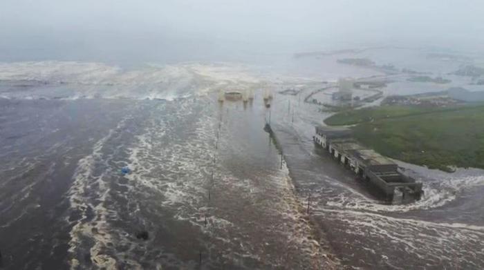
△On local time July 30th, Russia’s Sakhalin Territory
Leopold Lobkovsky, an academician of the Russian Academy of Sciences and an expert in international ecological and climate change issues, noted that the region had recently experienced quite strong earthquakes. On August 18th, 2024, a magnitude 7.
Level 0 earthquake; on July 20, 2025, a series of earthquakes occurred in the same area, with the strongest reaching a magnitude of 7.5.
Lobkovsky explained, “Initially, it was believed that these earthquakes relieved the accumulated plate pressure in the region, but later it was discovered that they were just precursors to today’s earthquake.”
Following the earthquake in the Kamchatka Peninsula, several people were injured but not seriously. Yevgeny Belyayev, the mayor of Kamchatka Peteropolk, stated on social media on July 30 that the city had been put into emergency mode due to the earthquake.
△On July 30, local time, in North Kruyshlersk, Russia
Solovodov, the administrative head of Kamchatka Territory, mentioned on social media that the earthquake caused the collapse of a wall at a kindergarten in Kamchatka Peteropolk City, fortunately without any casualties. According to the local health department, all those who sought medical treatment after the earthquake have been treated.
Kamchatka Peteropolk Airport announced that passengers were evacuated during the earthquake, one person was injured. The airport is now operating normally, with both runways and aprons unaffected.
According to the local emergency services, due to the epicenter being located in the ocean, the earthquake triggered a tsunami, which reached the coastline of the Ilyushinskiy district in Kamchatka Peninsula, with wave heights ranging from 3 to 4 meters. Additionally, multiple tsunami alerts were recorded in the Kuril Islands and the Northern Kurils. Limanenko, the governor of Sakhalin Oblast, stated that one tsunami submerged the port of Uchiryu and a fish processing plant in Uchiryu.
Global countries issued tsunami warnings
Furthermore, this earthquake triggered tsunami alerts for Pacific coastal countries such as Hawaii, Japan, and Chile. Some areas in French Polynesia were advised to prepare for waves up to 4 meters high. Tsunami waves were observed in many places.
In Japan, around 10:30 AM on the same day, the tsunami waves had already reached the northernmost part of Hokkaido.
Later that day, the Japan Meteorological Agency downgraded all tsunami warnings in Japan to a tsunami watch.
In Hawaii, California, Alaska, Guam, and other locations, different levels of tsunami warning mechanisms were activated. In California and Hawaii, tsunami waves have been detected. Warnings were sounded for all islands of Hawaii.
The National Emergency Management Agency issued tsunami warnings across the country’s coastlines. On the 31st local time, the National Emergency Management Agency of New Zealand issued another tsunami alert. It is reported that the tsunami has reached parts of New Zealand, with forecasts indicating that the intensity of the tsunami activity will increase over the next few hours.
On the 30th, the National Disaster Prevention and Response Center issued a red tsunami warning, demanding that residents in coastal areas evacuate to safe areas.